
How can data challenges impact disaster preparedness and response efforts
Uncover how mapping challenges and emerging technologies are reshaping global preparedness efforts and discover how:
- Data serves as a superhero in disaster planning, aiding in prediction and response, emphasizing the importance of accurate mapping data.
- Local knowledge combined with technology enhances disaster response effectiveness, highlighted by projects in Kenya and Abidjan.
- JAIC utilizes satellite data for real-time routing and emergency response, while global data sharing initiatives improve disaster preparedness through collaboration and emerging technologies.
Introduction
Imagine data as a superhero in disaster planning. By collecting, analyzing, and understanding data, we can predict potential disasters and make smart choices to keep people safe. But just like any superhero, data faces some tough challenges.
Even though we’ve seen incredible leaps in technology and many of creative solutions over the years, there’s still a big gap between what data could do and what it actually does for disaster management.
Let us explore the tricky problems we face with data in disaster planning and response, and some exciting new ideas to bridge that gap.
Mapping Challenges: Unveiling the Gaps
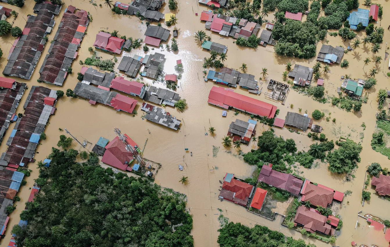
A major roadblock in disaster management is the lack of complete maps for many areas, especially those that do not have many resources. These communities often have spotty maps at best, making it difficult to figure out how vulnerable they are to disasters and plan the right response. Without accurate and up-to-date maps, navigating the complex details of a disaster zone becomes a real challenge. Even in areas with decent maps, there can be problems with coordination, which can slow or interfere with the flow of important information during emergencies.
The Power of Simple, Accessible Data
The concept of “Fancy vs Boring Innovation” introduces the idea that practical solutions often outweigh flashy technologies, especially in the realm of disaster response. The emphasis here is on having high-quality, accessible images that anyone can interpret.
This is where Mosaic shines, addressing the challenges of disaster response data with a focus on simplicity and accessibility:
Unparalleled Clarity: Mosaic captures data at an exceptional 12.3K – 13.5K resolution, providing the clearest possible images for detailed analysis.
Ready to Use, Anywhere: Mosaic’s mobile mapping camera systems are a complete solution with on-board storage, GNSS and GPU, eliminating the need for additional computers. Thanks to its robust industrial-grade construction (IP64), the systems can reliably capture in nearly any climate or weather conditions.
Seamless User Experience: Mosaic’s system caters to swift data acquisition for 360° street view mobile mapping. This simplifies data collection and streamlines the process for users.
By prioritizing these features, Mosaic ensures that critical information reaches all stakeholders involved in disaster management – from first responders to local authorities. This user-friendly approach allows for quick decision-making based on clear visuals, without the need for extensive technical expertise.
Mosaic exemplifies how straightforward yet powerful solutions can significantly improve disaster response efforts. Their commitment to providing accessible and reliable data plays a vital role in building resilient communities and facilitating more effective emergency response.
You can learn more about how Mosaic cameras are used to quickly collect, process and share data immediately after natural disasters here →
Training Local Workforces
An innovative approach gaining traction is the training of local workforces to interpret and utilize algorithms for disaster response. This strategy is currently being implemented in a project in Kenya, where high-resolution data specific to the region is used to generate training datasets. The rationale behind this initiative is the intimate knowledge that local workforces possess about their surroundings. What may be considered ‘damaged’ or in need of assistance can be highly location-specific, reinforcing the importance of contextualized disaster response.
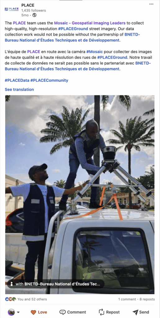
A notable example of this approach is evident in the collaboration between Mosaic and BNETD in Abidjan, known as PLACE. This initiative showcases the significance of detailed urban imagery in disaster preparedness. High-resolution street imagery, captured at street level, plays a significant role in mapping built and natural environments. The collaboration underscores the effectiveness of Mosaic’s geospatial imaging technology in capturing intricate urban details and highlights the value of such images in data collection for disaster response.
Limitations of Optical Data
Optical data, while invaluable, comes with its set of limitations, particularly in the context of weather-related events. Cloud cover, which often follows floods or other natural disasters, can obstruct optical data collection. As a countermeasure, the reliance on radar data is suggested, as it is not hindered by cloud cover. However, it is essential to recognize that radar data differs significantly from images, and striking the right balance between the two is crucial for effective disaster response.
Learn more about and compare various types of image data here →
Drones, often hailed for their potential in disaster response, were discussed in the Mapscaping Podcast, with a cautionary note regarding the overestimation of their capabilities. Both the coverage area and the speed of data processing by drones are frequently overestimated, and realistic expectations and careful consideration of their limitations are essential for incorporating drones into disaster management strategies.
While drones hold promise, their effectiveness can be limited by harsh weather. In contrast, 360-degree street view imagery capture from road vehicles offers a compelling alternative. This technology can capture data in nearly any climate, providing crucial information even when drone flights are grounded.
Check out one of our latest stories featuring the Mosaic X camera system as we drove across the United States, through various weather conditions, including many rainy days.
JAIC and the Golden Window after Disaster Strikes

Imagine a disaster hits, and help needs to get to people quickly. That’s where JAIC, a special team focused on using super-smart computers (AI) to help the Department of Defense, comes in. JAIC plays a critical role, especially in the first two weeks after a disaster when getting help to people fast is most important.
JAIC uses satellite data to see the conditions of assets on the ground, such as damaged roads, debris blocking the way, and even locating towns that might be completely cut off from help. This is where the idea of a “service area” becomes super important. It basically means figuring out where help needs to go as quickly as possible.
Using satellite data, JAIC can help map out the best routes to get aid to people who need it most. This is why working together and sharing information right after a disaster is so important. The faster everyone works together using this data, the faster help can reach those who need it most.
Sharing Data to Fight Disasters Better
Different countries tackle disaster planning in different ways, with some being much more high-tech than others. Some places are leading the charge using data to become disaster ninjas! For example, the European Union has a special program called Copernicus that uses satellites and other Earth-observational tools to gain fast and accurate info during disasters. In the United States, organizations like FEMA and NOAA use advanced data analysis to predict and track hurricanes, giving people more time to prepare.
But countries don’t have to go it alone! Working together is another way to use data effectively. Many countries have signed onto the Sendai Framework, a kind of agreement that highlights how important data is for understanding and reducing disaster risks. There’s also the GDACS, a team effort between the United Nations and the European Commission, that sends out real-time alerts and helps coordinate responses during disasters. These examples show how sharing data globally can make everyone better prepared for whatever Mother Nature throws our way.
Emerging Technologies in Disaster Response
Imagine having super-smart tools to help during a disaster. New technology is changing the game by making it easier to collect, analyze, and use data. Here are some of the gadgets on the frontline:
- Artificial Intelligence (AI): This super brain can crunch massive amounts of data to predict things like how strong a hurricane will be or where flooding might hit. This gives authorities time to warn people and get them to safety.
- Robots: Drones and other remote-controlled vehicles can fly into dangerous areas after a disaster to collect data. This helps first responders see what’s happening on the ground without putting themselves at risk.
- Sensors: Tiny devices like those in the “Internet of Things” can track things like water levels or air quality in real-time. This gives first responders a constantly updated picture of what’s going on in a disaster zone.
These technologies, working together like a superhero team, can make disaster response faster and more accurate. For example, AI can predict a hurricane’s path, then drones can remotely access the damaged areas, with operators at a safe distance, and sensors can track floodwaters for accurate feedback on the current state of things. This is the future of disaster response, and it’s all thanks to data!
Communities Fight Back Against Disasters
Imagine you’re living in a flood-prone town. Who knows the ins and outs of the area better than its residents? That’s why engaging communities in disaster planning is a crucial strategy. These citizen science initiatives empower ordinary people to contribute essential insights derived from their intimate knowledge of local hazards and conditions.
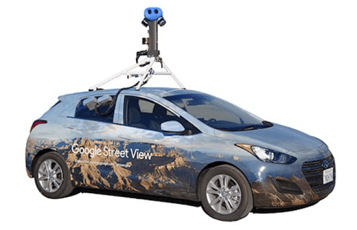
Relying solely on tools like Google Street View, while incredibly useful, is not sufficient for comprehensive disaster preparedness. While Google Street View provides valuable visual data, it may not always capture the most current information or subtle nuances of local geography that residents are keenly aware of. Therefore, incorporating community input alongside technology is essential for creating robust disaster response plans.
The Limits of Crowdsourcing for Disaster Response: Why Up-to-Date Data Matters
While Google Street View (GSV) serves as a valuable tool for everyday navigation and exploration in some parts of the world, its limitations become significant in disaster preparedness, particularly for developing countries.
Here’s why Google Street View is not a reliable source:
Outdated Information: GSV updates can be infrequent, especially in developing regions. This can lead to crucial infrastructure like new roads or bridges being missing from the data, creating discrepancies in disaster planning.
Incomplete Coverage: GSV coverage can be patchy in developing areas, leaving entire regions unmapped and hindering vulnerability assessments.
The Need for Reliable, High-Frequency Data
Effective disaster response hinges on dependable, up-to-date data collected frequently, ideally before a disaster strikes. This allows for a more accurate assessment of vulnerable areas, evacuation routes, and emergency shelters. Additionally, having a method for rapid data collection after a disaster ensures critical updates even when traditional infrastructure is damaged.
Collaboration and Up-to-Date Data: A Robust Approach
While Google Street View offers a glimpse into community knowledge in some regions, it cannot be the sole source for disaster preparedness, especially in developing countries. A more robust strategy combines:
Collaborative Efforts: Gathering resident input on local infrastructure and potential hazards.
High-Frequency Data Collection: Regularly capturing fresh, detailed data using specialized tools like Mosaic cameras.
Beyond Google Street View: A Reliable Solution for Disaster Response
For life-or-death situations, relying solely on Google Street View is risky. Up-to-date and reliable data gathered specifically for disaster response, like the kind Mosaic 360º Mobile Mapping Camera Systems provide, becomes paramount, particularly in developing countries facing unique infrastructure challenges.
By transitioning from potentially outdated crowdsourced data to high-frequency, high-resolution data collection, we can significantly enhance preparedness and response efforts in the face of disasters.
Finding the Right Balance
As data becomes more and more important in disaster management, there are some ethical issues to consider. One big concern is privacy. When it comes to using things like security cameras or phone data to help during disasters, it’s crucial to find the right balance between getting the information needed and protecting people’s privacy.
Luckily, there are guidelines in place to help with this, like the OCHA Data Responsibility Guidelines. These guidelines make sure data is handled responsibly during emergencies. They emphasize getting people’s permission before using their information, having clear rules about how data is shared, and keeping sensitive information safe. Striking this balance between using data effectively and respecting privacy is key to building trust and ensuring information is used responsibly.
A Team Effort to Beat Disasters
Just like superheroes work best together, different groups working together can make a huge difference in disaster preparedness. Here’s the dream team:
- Government Agencies: They have the big picture and know what resources are available.
- Non-Profit Organizations: They bring passion and expertise to the table.
- Private Companies: They have the latest tech and know-how.
When these groups work together, they can tackle data challenges head-on and come up with creative solutions. For example, tech companies can offer powerful data analysis tools, while government agencies can share crucial on-the-ground information.
A great example of this teamwork is the Global Partnership for Sustainable Development Data. This group brings together governments, businesses, and everyday people to use data for good, including disaster preparedness. By working together, these partnerships can make data-driven strategies even more effective, leading to faster and more coordinated responses to disasters.
The Future of Disaster Management
The future of disaster management is looking bright, but there are still some hurdles to overcome. New technologies like artificial intelligence (AI), the Internet of Things (IoT), and advanced data analysis are constantly evolving, offering even more powerful tools for predicting, responding to, and recovering from disasters. However, challenges like making sure different data systems can work together (data interoperability) and creating clear standards for how data is used (standardization) still need to be addressed to unlock the full potential of these innovations.
The key to success lies in combining real-time data from many sources with even better prediction models. This will allow for quicker and more targeted responses during disasters. AI will also play a bigger role in analyzing data and making decisions automatically, which will streamline response efforts. As disaster management keeps evolving, being proactive about tackling challenges and embracing new technologies will be crucial in building a strong and effective global system to fight back against disasters.
Conclusion
In conclusion, navigating the complexities of data in disaster preparedness and response reveals a diverse array of challenges, from incomplete mapping in underserved regions to the limitations of optical data during adverse weather conditions. Despite these obstacles, innovative approaches, such as training local workforces and embracing high-resolution imagery, show promise.
It is essential to recognize the limitations of existing technologies, including drones, and strike a balance between various data sources, such as radar data. Organizations like JAIC, utilizing satellite data for real-time routing and emergency response, exemplify the pivotal intersection of technology and disaster management. As the field advances, addressing challenges and adopting context-specific strategies will be vital in enhancing global disaster preparedness and response efforts.
By harnessing the potential of innovative solutions, and acknowledging the limitations of existing technologies, the global community can better prepare for and respond to the escalating frequency and severity of natural disasters.
Contact our team today to learn more.
