
Choosing 360 imagery for GIS applications: your ‘go-to’ for clear data in inspections and to share with the masses, more rapidly, quickly, and frequently
Introduction
In today’s rapidly evolving technological landscape, Geographic Information Systems (GIS) have the ability to transcend traditional mapping techniques to embrace immersive, real-time visualization capabilities. At the forefront of this revolution is 360-degree imagery, a dynamic tool that allows users to “be there from anywhere,” offering unprecedented access to remote or challenging environments. This innovative approach not only enhances user experience but also broadens the scope of applications from urban planning and disaster response to infrastructure management and beyond.
Mosaic, a leader in high-resolution mobile mapping camera systems, is pioneering the integration of 360-degree imagery with GIS technologies. Through Mosaic’s advanced camera systems, users can capture detailed panoramic images that offer a comprehensive view of any location, transforming how data is collected, analyzed, and shared. The fusion of high-resolution imagery and GIS creates a powerful platform for decision-making, enabling stakeholders across various sectors to make more informed choices quickly and efficiently.
As we dive deeper into the capabilities and benefits of immersive GIS, it becomes clear that this technology is not just about seeing the world from a new perspective—it’s about interacting with it in real-time, making geospatial data more accessible, and driving efficiencies in ways we’ve only just begun to explore.
Understanding 360 Imagery
360-degree imagery, often referred to as panoramic photography, is a revolutionary visual technology that captures a complete spherical view of the surroundings. This technology stitches together multiple images or videos from different angles into a single, cohesive panoramic image. As a result, users can view a scene in every direction from a fixed point, providing a truly immersive experience.
Technological Spectrum of 360 Imagery Solutions
1. Prosumer-Grade Solutions:
Accessibility and Affordability: At the entry-level, prosumer-grade cameras such as the GoPro or Insta360 models are popular. These devices are highly accessible, easy to use, and affordable, making them ideal for hobbyists, small businesses, and educational purposes.
Applications: Although they offer lower resolution compared to higher-end models, these cameras are suitable for creating virtual tours, basic asset documentation, and social media content where ultra-high resolution is not critical.
2. Mid-Range Solutions:
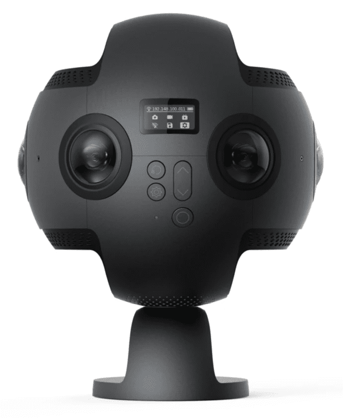
Mosaic X Camera System
The Mosaic X is designed from the ground up for high-speed data capture and is optimized for mobile mapping with a global shutter that ensures high-quality image capture even at highway speeds. It features industrial-grade durability and hot-swappable storage, making it suitable for extended, uninterrupted use in demanding environments. The camera captures detailed 360° imagery quickly, outpacing other solutions in its class. With six 12-Megapixel image sensors, the Mosaic X provides excellent photogrammetry and 3D reconstructions, making it the only all-in-one 360° solution optimized for such detailed applications.
NC Tech iStar Pulsar (no longer for sale)
The NC Tech iStar Pulsar is known for its portability and ease of use, offering good quality panoramic imaging with decent resolution. While it does not match the Mosaic X in terms of raw power and the ability to capture high-resolution images at high speeds, it provides a viable option for users needing a more compact solution for less demanding environments.
Ladybug Cameras
Ladybug cameras are one of the industry standards for camera sensors. They offer coverage with multiple lenses that work together to cover 360º. However, they require additional hardware in the vehicle during data capture and while they have increased resolution in the last edition (Ladybug 6), the image quality does not seem to have improved as much as reported by users.

3. High-End Professional Solutions:
Advanced Capabilities: At the top of the range are high-end systems that integrate 360-degree cameras with advanced technologies such as LiDAR and Inertial Measurement Units (IMUs). These systems, often costing tens of thousands of dollars, provide extremely high accuracy and resolution.
Applications: They are crucial in fields requiring precise measurements and high fidelity, such as advanced geographic surveys, detailed urban planning, and critical infrastructure monitoring.
Cost Implications: While these systems offer unmatched capabilities, their high cost makes them suitable primarily for large-scale commercial and industrial applications.
As discussed in one video,
“A solution like LiDAR is going to be absolutely overkill for being able to evaluate the presence, just the presence, of this tree laying on the lines. But with 360 imagery it makes it easy to drive directly to this location to see what’s going on.”
Barry Bassnett
To read more about the industries most well-known and widely respected 360 mobile mapping cameras, check out this article here →
Integration with LiDAR and IMUs
High-end 360 imagery systems frequently incorporate LiDAR (Light Detection and Ranging) technology and Inertial Measurement Units (IMUs). LiDAR provides precise distance measurements by bouncing laser light off surfaces and capturing the reflected light. When combined with the comprehensive visual data from 360 cameras, LiDAR data enhances the spatial accuracy of the imagery, making it invaluable for detailed mapping and 3D modeling.
IMUs contribute by tracking movement and orientation, which is essential for accurately aligning and stitching the captured images in challenging environments, such as moving vehicles or unstable terrains. The integration of these technologies allows for creating detailed, accurate virtual environments that can be invaluable for complex analysis and decision-making processes.
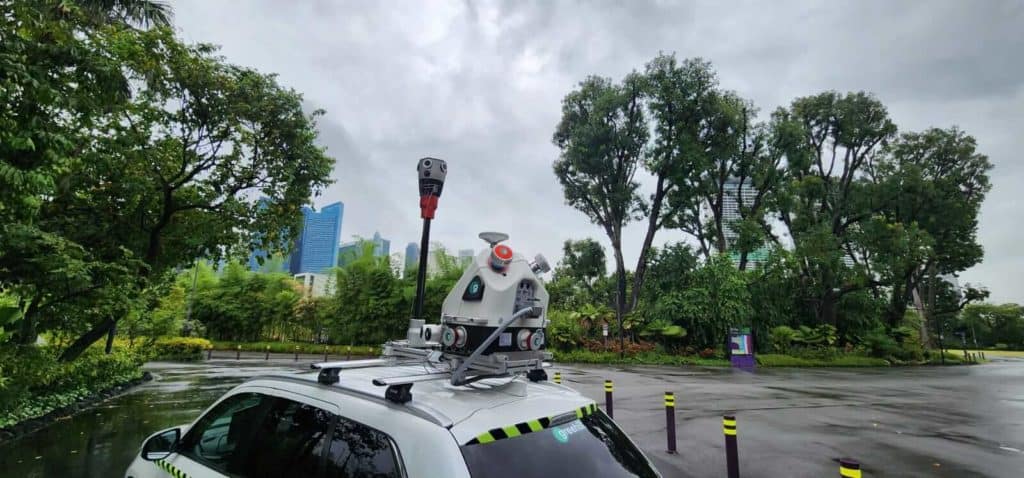
Mosaic mobile mapping cameras were purposely designed to be able to operate as standalone units or as a part of a larger mobile mapping setup. They are capable of integrating with most industry standard sensors.
Check out these two integrations with external devices, ensuring Mosaic customers can achieve the desired accuracy and precision that meets their or their customers’ demands. →
The Value of 360 Imagery in Modern GIS
The integration of 360-degree imagery with GIS systems marks a significant leap forward in how geographical data is visualized and interpreted. This integration allows users to immerse themselves in remote locations and examine the details as if they were physically present, enhancing the understanding of spatial relationships and physical characteristics across diverse landscapes.
Moreover, the varying levels of technology—from prosumer to professional—ensure that there is a 360-degree imaging solution available for every need and budget, democratizing access to advanced visualization tools and expanding their use beyond traditional expert domains.
Key Applications of 360º Imagery
360-degree imagery has revolutionized several industries by providing an immersive, comprehensive view of environments that can be crucial for decision-making and operations management. Building off of a conversation between Barry Bassnett, a pioneer in the 360º imaging sphere, and his guest Anthony Grescavage, from Nodeology which specializes in getting 360° photos and videos into ArcGIS, here are some key sectors where 360-degree imagery is making a significant impact.
Watch the full video between Anthony and Barry here →
Disaster Response and Emergency Management
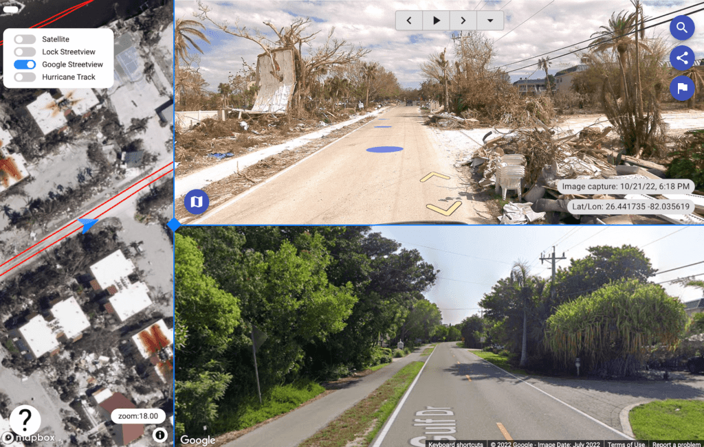
Rapid Assessment: In the aftermath of disasters such as hurricanes or earthquakes, quick and accurate assessment is crucial. 360-degree imagery enables emergency responders to visualize the extent of damage remotely, facilitating faster and more efficient responses. For example, post-Hurricane Ian, 360 imagery provided by Mosaic’s customer to major disaster management organizations helped visualize damaged areas before field teams could access them, significantly speeding up the recovery process.
Accessibility of Data: The imagery allows for immediate understanding and assessment of the situation, which is vital when coordinating large-scale emergency responses. This imagery can be rapidly shared with multiple stakeholders, ensuring that everyone involved in the disaster recovery has the most current information without needing to be physically present.
Read more about how 360 imagery and mobile mapping cameras can help in pre and post disaster and emergency management →
Insurance and Claims Processing
Efficient Damage Evaluation: Insurance companies can utilize 360-degree imagery to assess claims more effectively. For instance, insurers can remotely evaluate the damage to properties, which reduces the need for on-site claims adjusters and speeds up the processing of insurance claims.
Documenting Pre and Post-Loss Conditions: 360-degree cameras can capture detailed pre-loss conditions that can be invaluable when assessing claims, providing a clear and indisputable record that can help resolve claims more swiftly and transparently.
Learn how one Mosaic user captured and shared data within 24 hours post Hurricane Ian with FEMA and and the National Disaster Preparedness Training Center →
Utility and Infrastructure Monitoring
Power Line Inspections: As highlighted in the discussion, 360-degree imagery simplifies the monitoring and maintenance of power lines and other critical infrastructure. This technology can replace more costly and logistically complex methods like LiDAR in certain contexts. For example, utilities can use 360 imagery for routine inspections of power lines, identifying issues such as vegetation encroachment or damage from storms without the need for physical site visits.
Cost-effective and Continuous Monitoring: The ability to deploy cameras continuously over extended periods allows for ongoing monitoring of infrastructures such as roads, bridges, and public utilities, making it easier to spot potential problems before they become critical.
Learn more about how one Mosaic customer deploys 2 different systems – the Mosaic 51 camera system as a standalone system or with additional sensors including LiDAR to meet the demands of their electrical grid or road inspection projects. →
Enhancing Disability Access
Accessibility Mapping: 360-degree imagery is also instrumental in improving accessibility for individuals with disabilities. By mapping routes and facilities, municipalities and organizations can better plan and implement accessibility improvements. This application not only aids in compliance with regulations but also enhances the quality of life for people with mobility challenges.
Environmental and Urban Planning
Detailed Environmental Documentation: In urban planning and environmental conservation, 360-degree imagery provides detailed records of landscapes, cityscapes, and natural reserves, helping planners and decision-makers visualize changes over time and assess environmental impact without frequent field visits.
Public Engagement: Enhanced imagery allows for greater public involvement in planning processes by providing stakeholders with a realistic view of proposed changes or developments, thereby fostering a transparent and inclusive planning process.
Mosaic customer greehill combines their Mosaic X camera systems with RIEGL mobile mapping systems for urban greenery inspection and planning. Learn more here →
These applications of 360-degree imagery illustrate its versatility and the value it brings to various industries. By enabling detailed visual documentation and rapid data sharing, 360-degree imagery not only enhances operational efficiencies but also supports critical decision-making in dynamic environments. As we continue to explore the advantages and benefits in the next section, we will delve deeper into how these capabilities translate into tangible benefits across different sectors.
The Advantages of Using 360º Imagery
360-degree imagery offers a myriad of advantages across various sectors, enhancing both operational efficiency and decision-making capabilities. The conversation between Barry and Anthony, along with additional insights, reveals several key benefits that underscore the transformative impact of this technology.
Cost-effectiveness
Reduced Operational Costs: Utilizing 360-degree imagery can significantly reduce the costs associated with traditional survey and monitoring methods. For example, when compared to LiDAR and other high-end survey technologies that require expensive equipment and specialized operators, 360-degree cameras offer a more affordable alternative that still delivers high-quality data. As mentioned in the discussion, the ability to use mid-range cameras like those from Mosaic mitigates the need for heavy investment in high-cost equipment.
Decreased Need for Physical Site Visits: In sectors like insurance, real estate, and disaster management, the ability to conduct virtual site visits saves substantial costs related to travel and manpower. After events like Hurricane Ian, the rapid deployment of 360 imagery allowed for immediate assessment, thus expediting response efforts and reducing the logistical burden of sending multiple teams onsite.
Rapid Collection and Enhanced Visualization
Speed of Data Acquisition: One of the standout features of 360-degree imagery is its ability to rapidly capture comprehensive visual data. This rapid collection is crucial in time-sensitive situations such as post-disaster assessments where every minute counts. The example from the discussion highlighted how imagery captured immediately after Hurricane Ian provided critical data long before traditional survey teams could be mobilized.
When time counts, satellite imagery can take time to show the true destruction immediately after, but with 360 street view imagery, you can see in near real time the situation at hand.
“The speed of collection and the easy deployment has to be a major benefit for people,”
Barry Bassnett
“Operating that piece of equipment, you’re going to be limited in how frequently you could deploy it and the cost for whatever projects you’re looking at is going to be driven up as well. And that all factors into your timeline so you can’t deploy those solutions as frequently,”
Anthony Grescavage
High-Quality Visualization: 360-degree imagery offers a detailed and immersive view of environments, making it easier for stakeholders to understand and assess conditions remotely. This capability is particularly beneficial for detailed inspections and planning, where visual accuracy is paramount.
The result of Site Tour 360’s workflow, utilizing Mosaic 51 camera data
Project Funding Provided By:
Site Tour 360 – Interactive Mapping & 360 Imagery Collections
The University of Hawaii and the National Disaster Preparedness Training Center (NDPTC)
Structural Extreme Events Reconnaissance organization (StEER) and the National Science Foundation (NSF)
Accessibility and Ease of Use
User-Friendly Technology: The simplicity of operating 360-degree cameras makes this technology accessible to a wide array of users, not just GIS professionals. Mosaic’s camera systems, for instance, are noted for their ease of operation, allowing individuals with minimal training to effectively capture and utilize high-resolution imagery.
Broader User Base: The ability to easily share and view 360-degree imagery democratizes access to detailed geospatial data. As discussed, this makes the technology invaluable to fields such as emergency management, urban planning, and public safety, where diverse teams need quick access to accurate, comprehensive visual data.
“You don’t need to have a degree in surveying or be a registered surveyor or anything. You can put this in the hands of First Responders or trained individuals on how to use it,”
Barry Bassnett
Integration with GIS and Other Technologies
Seamless Integration with GIS Platforms: 360-degree imagery integrates smoothly with GIS systems, enhancing the spatial analysis capabilities by providing an additional layer of visual data. This integration allows for more nuanced analyses and better-informed decision-making, as users can overlay traditional GIS data with real-time imagery.
“A big advantage of using 360 the imagery is you don’t necessarily need to be highly GIS literate highly geospatial data literate to get in here and and traditionally you had the GIS market… making this sort of thing more readily available to people outside of hardcore GIS analyst and and LiDAR folks,”
Barry Bassnett
Enhancements Through AI and Machine Learning: Advanced 360-degree imaging systems can be further enhanced by AI technologies for features like automatic defect detection or change monitoring, increasing the utility and accuracy of the captured data over time.
These advantages demonstrate why 360-degree imagery is becoming increasingly integral to various industries. Its impact on cost, efficiency, and data quality makes it an invaluable asset in our increasingly data-driven world. The next sections will continue to explore how these benefits are applied across different use cases and the future prospects of 360-degree imagery technology.
Integrating 360º Imagery with GIS
The integration of 360-degree imagery with Geographic Information Systems (GIS) represents a significant advancement in how spatial data is visualized and utilized across various industries. This integration not only enhances the capabilities of GIS platforms but also extends their applicability to a wider range of users and use cases. Drawing insights from the conversation between Barry and Anthony, along with the highlighted points in the transcript, this section explores how 360-degree imagery enhances GIS functionalities.
Check our Mosaic’s own test in which we mapped a whole town and through the use of Mapillary, were able to extract features and then enable further integration with ArcGIS for richer geospatial visualizations →
Enhancing Spatial Analysis with 360 Imagery
Richer Data Visualization: 360-degree imagery adds a visual dimension to the GIS data that is more intuitive and comprehensive. Users can virtually navigate a location as if they were physically present, examining details that might not be evident in traditional top-down mapping views. This immersive experience is crucial for fields requiring a deep understanding of spatial environments, such as urban planning and disaster response.
Real-Time Data Integration: Mosaic’s camera systems, which capture high-resolution images along with precise GPS coordinates and timestamps, allow for seamless integration with GIS platforms. This integration enables real-time updating and visualization of spatial data, enhancing the timeliness and relevance of the information available to decision-makers.
Applications in Various Industries
Emergency Management: In disaster management, integrating 360-degree imagery with GIS allows emergency responders to quickly assess damage, plan logistics, and execute recovery strategies more efficiently. The ability to overlay real-time visual data onto GIS models helps in understanding the extent of damage and prioritizing response efforts based on visual assessments.
Infrastructure Monitoring: For utilities and infrastructure, the integration allows continuous monitoring and maintenance planning. GIS can help track the condition and changes over time, while 360 imagery provides the immediate visual context, enhancing the accuracy of maintenance schedules and interventions.
Streamlining Workflows
Automated Data Processing: Advanced GIS platforms equipped with tools for processing 360-degree imagery can automate many aspects of data handling and analysis. For instance, features extracted from the imagery can be automatically geolocated and added to GIS databases, streamlining workflows and reducing manual labor.
Collaborative Platforms: GIS platforms can serve as collaborative tools where teams from various sectors—ranging from urban development to environmental conservation—can work together. The visual data from 360-degree cameras enhances the collaborative aspect by providing a common visual reference that is easy to understand and discuss.
Future Prospects and Innovations
The future of 360-degree imagery in GIS and related fields is bright, with ongoing advancements expected to expand its capabilities and applications even further. As technology evolves, the integration of 360 imagery with emerging technologies such as artificial intelligence (AI), machine learning, and the Internet of Things (IoT) promises to unlock new potentials and streamline processes across various industries.
Enhancements Through AI and Machine Learning
Automated Analysis and Feature Recognition: Future developments include more sophisticated AI algorithms capable of analyzing 360 imagery to identify and classify features automatically. This can significantly reduce the time required for data processing and enhance the accuracy of the data captured, especially in complex environments like urban areas or during disaster response operations.
Predictive Analytics: Integrating predictive analytics with 360-degree imagery could foresee changes in environments, aiding in everything from urban planning to climate change mitigation strategies. This can help planners and decision-makers anticipate problems before they occur, ensuring resources are allocated more effectively.
“We’re looking to employ AI and other technologies to help improve the geolocation and precision of the 360 imagery itself, based on the contents of the imagery and the relation between images.”
Anthony Grescavage
Integration with IoT
Real-Time Monitoring and Response: As IoT devices become more prevalent, their integration with 360-degree imaging systems could lead to real-time monitoring and response solutions across various sectors. For example, sensors placed along infrastructure can feed real-time data into GIS systems, enhanced by visual context provided by 360 imagery, allowing for immediate actions to be taken in response to data received.
Expanding Accessibility and User Engagement
Virtual Reality (VR) and Augmented Reality (AR): The use of VR and AR with 360-degree imagery can transform how users interact with GIS data. For example, urban planners could use VR to immerse themselves in virtual replicas of cityscapes that integrate real-time data overlays, enhancing understanding and engagement with the spatial data.
Public Participation: As 360-degree cameras become more accessible and easier to use, public involvement in data collection and monitoring could increase. This would democratize GIS data further and increase community involvement in local development and environmental conservation efforts.
Sustainable Practices and Global Reach
Environmental Monitoring: Enhanced 360-degree imagery could play a crucial role in global efforts to monitor and combat environmental issues. High-resolution imagery can track changes in ecosystems over time, providing invaluable data for conservation efforts.
Education and Training: As the technology becomes more integrated into everyday devices, its use in educational contexts will likely increase, providing students and professionals with hands-on experience in analyzing and understanding geospatial data.
Are you ready for immersive 360 imagery for GIS applications?
360-degree imagery has already begun to transform numerous industries by providing detailed visual insights integrated seamlessly with GIS data. As discussed in the conversations between Barry and Anthony, this technology not only enhances operational efficiency and decision-making but also makes geospatial data more accessible to a broader audience.
The future developments in AI, machine learning, and IoT integration are poised to further enhance the capabilities of 360-degree imagery, making it an indispensable tool in urban planning, disaster response, infrastructure management, and environmental monitoring. As we continue to innovate and integrate these technologies, the potential for 360 imagery to revolutionize our understanding of and interaction with the world around us grows exponentially.
By embracing these advancements, professionals across various sectors can expect to achieve greater accuracy in their work, engage more deeply with the data, and foster a more informed and involved public. As Mosaic and other leaders in this field continue to push the boundaries of what’s possible, the future of 360-degree imagery and GIS integration looks not only promising but transformative for the global community.
