Mosaic is expanding the frontier for mobile mapping and wearable SLAM beyond vehicle-mounted cameras and aerial drones with the Mosaic Xplor.
Wearable SLAM is pushing the boundaries of mobile mapping
Data is king, and the versatility of mobile mapping backpacks, or wearable SLAM (simultaneous localization and mapping), is unlocking new data collection possibilities for many industries. As of the posting of this article, the world has produced 147 zettabytes of data in 2024 and a projected 181 zettabytes in 2025. According to the latest estimates, 402.74 million terabytes of data are created each day, but having the right data and the right technology to collect it is not always easy to come by.
Wearable SLAM is the next major step in technological innovation to map our world in hard-to-reach areas. Data that was once impossible or too expensive to collect is now more accessible than ever.
Mosaic is pushing industry boundaries with the Mosaic Xplor, a 360º mobile mapping backpack made to explore, capture, and analyze hard-to-reach environments. It has our signature high-resolution imagery and cutting-edge 360º x 104º LiDAR.
Use cases for wearable SLAM
Creating digital twins, 3D point clouds, and 360° virtual tours used to be relegated to only the most highly technical departments with large budgets, but not anymore! Mobile mapping and scanning are becoming cheaper and easier with each passing year. Now, various industries use these technologies to streamline their processes and create higher-quality deliverables for their clients.
The Mosaic Xplor and other wearable SLAM devices are making it easier to create many of these common projects:
Indoor Mapping and Building Layouts
These systems are ideal for creating detailed layouts of complex buildings like hospitals, schools, and corporate offices. Detailed maps aid professionals in space management and emergency response planning.
The real estate industry also utilizes mobile mapping to create 360° virtual tours for perspective clients, interior designers, and engineers. Still photos and traditional videos distort spaces and make it difficult to imagine yourself in the space, but wearable SLAM is changing industry standards. This reduces the costs associated with multiple on-site tours and broadens the marketing opportunities for renting and selling commercial spaces, apartments, and hotel rooms.
Infrastructure and Construction Monitoring
Wearable SLAM and the AEC industry go hand-in-hand. These versatile mobile mapping devices can capture 3D point clouds and 360° imagery for digital twins and inspections. The imagery can also be used with VFX for sales and marketing purposes.
High-resolution imagery is especially useful for communicating details with clients who may not have a lot of knowledge on interpreting 3D textured mesh or point clouds.
Environmental and Geological Surveys
Conducting environmental studies in sensitive ecosystems like wetlands, forests, and coastal areas may require a person to gather data on foot. In the photo below, you can see the creative solution from Site Tour 360. They needed a wearable SLAM device to gather imagery on a walking path in the wetlands, so they took the Mosaic 51 and customized a portable mount that fit their needs.

Cultural Heritage and Historical Documentation
Important cultural sites, such as ancient ruins, castles, and sacred religious sites, are often in locations inaccessible to vehicles. Mobile mapping backpacks enable historical societies to document historical sites from both indoor and outdoor perspectives. Go into tunnels, through narrow doors, and under arched walkways with wearable SLAM technology.
Check out Mosaic 51’s scan of St. Barbara Cathedral in Prague on Prevu3D.
Event Planning and Management
Event coordinators use mapping backpacks to plan large events in spaces like stadiums, concert halls, and convention centers. Having an accurate representation of the indoor space helps with logistics, crowd management, and security planning.
Disaster Response and Risk Assessment
In post-disaster scenarios like earthquakes or floods, mobile mapping backpacks allow for rapid assessment of affected areas, particularly in regions where roads are damaged or inaccessible.

What sets the Mosaic Xplor apart

Image Quality
What sets the Mosaic Xplor camera apart from other mobile mapping backpacks like the NavVis VLX series or the Z&F FlexScan 22 is its emphasis on high-resolution imagery.
While competitors typically rely on LiDAR technology, which may ignore or downplay the importance of image data, the Mosaic Xplor places cameras and image quality at the forefront of its design.
Equipped with six 12.3-megapixel image sensors, this system captures stunning 13.5K resolution panoramic images, providing the photorealistic detail that LiDAR-centric systems often overlook.

Capture Speed
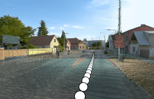
Don’t let inefficient cameras and heavy equipment slow you down! The Mosaic Xplor’s ability to collect data at walking speeds (and even up to 25 km/h on bicycles or scooters) offers a level of efficiency unmatched by other systems.
Many competing devices, like the NavVis VLX 2, require the operator to pause completely when capturing images. Stopping to take a photo every few meters drastically slows down the mapping process, but with the Mosaic Xplor, users can continue capturing data while on the move. It is ideal for fast-paced environments like city mapping and industrial inspections.
Let’s do the math
In this scenario, you want to capture imagery at every meter for 100 meters. The average walking speed is 4 km/hr.
With the Mosaic Xplor, you can walk continuously and do it in 90 seconds (1.5 minutes). You could also hop on a bike, scooter, or motorcycle and be done in 30 seconds.
With the NavVis VLX 2, you must stop every single meter to take a photo. If it took 2 seconds to stop and capture every image, it would take you 290 seconds (4 minutes and 50 seconds) by foot. Forget hopping on a motorcycle for this data capture!
Multiply those precious minutes by hundreds of meters, and you end up with a very expensive and time-consuming project. With the Mosaic Xplor, you can keep your best employees doing the highly technical tasks instead of walking and stopping around job sites.

Key Features of the Mosaic Xplor
12-bit RAW and h.264 Imagery: With six global shutter cameras, the Mosaic Xplor produces equirectangular panoramas with 13.5K resolution, ensuring ultra-high image quality.
Dual LiDAR Units: While focused on imagery, the Xplor also integrates two LiDAR sensors, capturing up to 400,000 points per second. It is a highly versatile tool for both image and point cloud data collection.
Nonproprietary Data Formats: Unlike many other systems that lock users into specific software ecosystems, the Mosaic Xplor provides open, non-vendor-locked formats. Integrate your data into an already existing software that matches your workflow and has the tools you need for your specific project.
Data Ownership: Capture the data you need, when and where you need it. When you own your hardware, you own your data-collection timeline! There is no need to wait for drone permits, arrange meetings with aerial surveying companies, or wait for an available car. There are many benefits to owning your data, like no annual subscriptions and no off-shore data storage.
Portability: The Xplor only weighs 7kg/15 lbs, of which only 2 kg/4.4 lbs are overhead. It is designed for ease of use, whether you’re navigating pedestrian zones, rugged landscapes, or confined indoor spaces. A single operator can walk, bike, or ride a motorcycle while capturing data. The Xplor is also battery powered, so it goes wherever you need imagery without needing cables or an external energy source.
Simplicity: The Xplor is nearly an off-the-shelf user experience while still capturing industrial-grade data. With simple controls, a removable 1T SSD card, and an all-in-one backpack design, a single operator without much previous training can gather imagery data at speeds up to 25km/h (15.5 mph). Have consumer-level simplicity that still delivers professional results.
Durability: The Mosaic Xplor reliably operates in remote locations without access to WiFi or cellular networks. It is also stress-tested for high humidity and rugged conditions. It is IP64 certified but has been field-tested to IP67 conditions.
Conclusion
The Mosaic Xplor isn’t just another wearable SLAM device; it is a revolutionary tool that combines photorealistic imagery with the flexibility to map areas previously deemed too complex or inaccessible. With Xplor’s focus on camera-based data capture, portability, and the ability to operate at speeds up to 25 km/h, it is leading the charge in mobile mapping innovation.
Whether you’re planning a city’s infrastructure, documenting a historical landmark, or managing large-scale industrial projects, The Mosaic Xplor is the solution that gets the job done with unmatched efficiency and accuracy.
Expand your horizons with the Mosaic Xplor and the mobile mapping revolution.
If you are looking for a ‘go anywhere’ solution, contact us today.