3D city modeling plays a pivotal role in advancing innovative urban development. Build a 3D model of a city to turn a beautiful imagination into reality!
This article was updated in February 2025.
Why is it important to create a 3D model?
Constructing a 3D model of a city is essential for effective urban planning, infrastructure development, and environmental analysis. At their core, these 3D models provide a comprehensive visual representation of urban spaces. They enable planners, architects, and policymakers to assess spatial relationships, land use patterns, and potential development impacts.
What are the benefits of 3D city modeling?
When it comes to 3D city modeling, it is important to focus not only on building infrastructure but also on the entire context of the urban environment. This added context includes the terrain, monuments, transportation networks, and pedestrian interactions. In short, 3D city modeling helps urban planners and city managers see the whole picture.
Informed decision making
Decisionmakers who have never visited the city now have options to interact with the built environment digitally. This saves time and money and improves efficiency.
By integrating data from geographic information systems (GIS), remote sensing, and photogrammetry, 3D city models support informed decision-making. They help optimize transportation networks, disaster preparedness strategies, and sustainable growth initiatives. 3D models are also important for public relations because they make complex planning proposals more accessible and understandable to stakeholders.
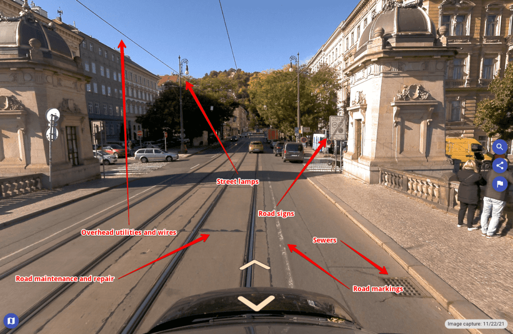
Mosaic’s Meridian mobile mapping camera system integrates high-resolution imagery with the precision of LiDAR to deliver a product that meets all your project’s mapping needs. It allows users to take precise measurements and dimensions required for urban infrastructure, mapping streets, hiking trails, and railways.
Integrating digital transformation technology
3D city models also play a crucial role in the digital transformation of urban management. They support the implementation of smart city technologies by integrating real-time data on traffic, energy consumption, and environmental conditions. These models enhance simulations for flood risk assessments, shadow studies for optimizing building placements, and visibility analyses for infrastructure planning.
Digital twins that have been semantically enhanced have the potential to be significant centers of integrated data for computer-based urban spatial analysis. As digital representations of cities, 3D city models can be used for a variety of purposes, including urban wind and dispersion simulations, noise studies, energy studies, and other forms of study that need a proposed architectural design to be placed in its context.
Democratization of information
The digital transformation of many industries is also resulting in more realistic renderings that accurately portray the appearance and textural information of urban spaces. Thanks to a 3D city model, industry experts and laypeople can observe the locations in an understandable and user-friendly method.
Observations from multiple angles
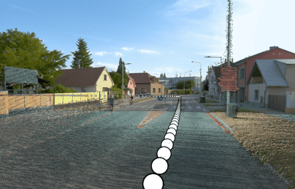
Unlike a physical visit to a proposed site, 3D models can be rotated and altered to create multiple points of view. Combine drone, aerial, and satellite footage with street-view data capture to create models that include roofs and bird’s eye views of urban environments.
3D mapping technologies can aid in analyzing ventilation, visibility, and light distribution between structures. They also offer the shapes and proportions of landscape elements and buildings in a given area and facilitate the management of large amounts of data. Because of these advantages, this technique is quickly gaining traction in topographic mapping and smart city planning.
How to build a state-of-the-art 3D model of a city
When you build a 3D model of a city, it’s easy to picture how a new building, solar panel installation, or bridge will affect the surrounding area. Once a plan has been proposed and integrated into the model, it may be used to communicate with partners and the general public. These models are useful for situational awareness and emergency reactions, in addition to general urban planning tasks.
Geographic information system (GIS) technology is a key tool for visualizing these accurate models alongside other layers. Governments may readily adapt 3D cityscapes to represent new buildings, new materials, and even shifting landscapes, unlike physical models or two-dimensional drawings.
There are various software that Mosaic mobile mapping camera systems integrate with for developing a 3D city model.
3D photogrammetry processors
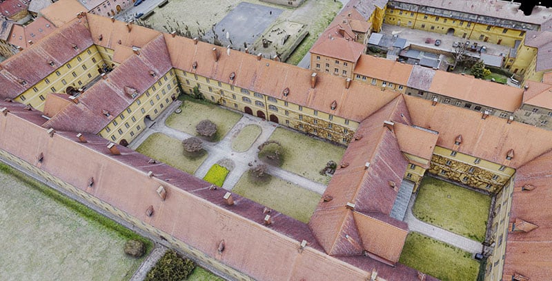
A 3D model processor, such as Skyline, Metashape or iTwin, takes imagery captured by 360 cameras and transforms it into detailed 3D models through a process called photogrammetry. The imagery is processed and aligned with geospatial data to create accurate digital twins, which are used for infrastructure analysis and management.
Processors can extract 3D point clouds, meshes, and textures, which are then used to generate highly accurate and realistic 3D models. All of these platforms leverage the high-resolution data captured by 360-degree cameras to produce models that are crucial for applications in urban planning, surveying, and construction.
3D model viewers
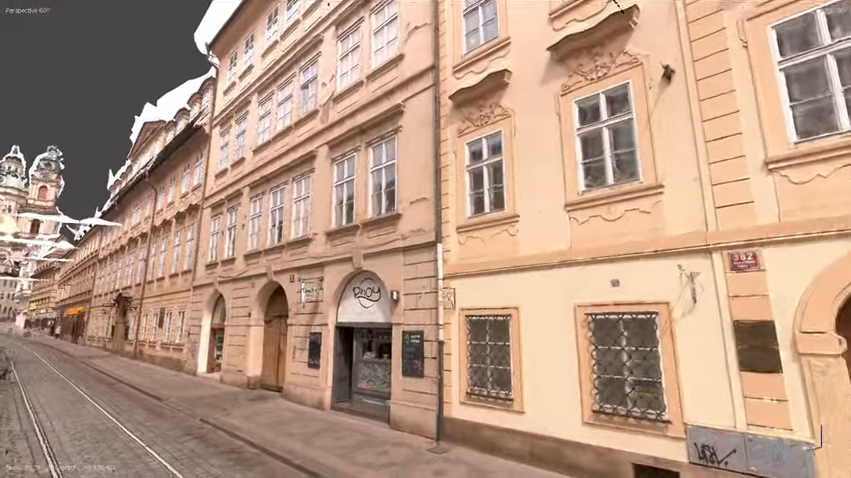
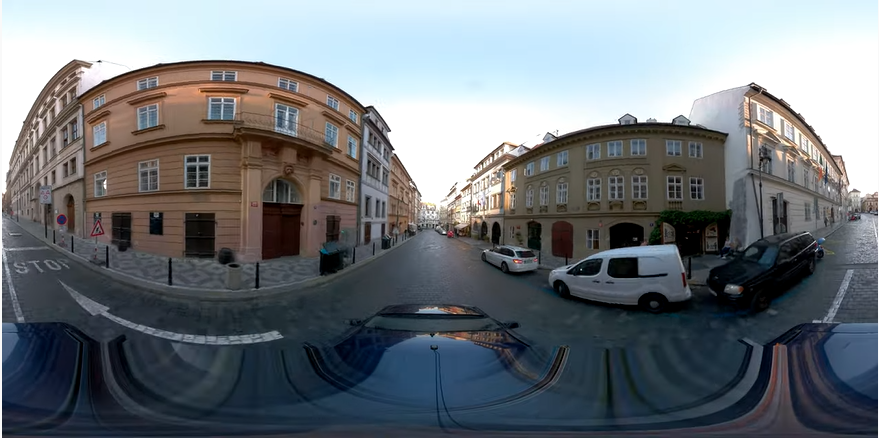
After processing, view your dataset with a 3D model viewer, such as Prevu3D or Cesium. These viewing platforms allow users to view and navigate 3D models with tools for measurement, markup, and collaboration. They aid in facilitating detailed examinations of designs and construction data. Below you can see a 3D model rendered with Mosaic X camera data, and uploaded to UnrealEngine5 via THE Cesium plugin. Check out as the car navigates the narrow, historical streets of Prague.
The market trends for 3D mapping and modeling
The evolving demands of the modern market have led to a notable increase in the adoption of 3D mapping and modeling across multiple industries.
3D modeling for the military, aerospace, and defense
The demand for 3D mapping and modeling solutions has grown in recent years, particularly in the defense, military, and aerospace industries. These solutions improve geospatial intelligence and situational awareness across domains for continuous monitoring and surveillance programs, crisis intervention efforts, and broad area mapping.
3D mapping for driverless cars
The popularity of 3D mapping is likely to rise in the future as the number of driverless cars increases and other automated transportation systems grow. This trend necessitates custom-designed maps and open-source routing engines for navigation. With this, more road mapping and high-resolution 360-degree cameras have been introduced to the market. These types of cameras can also be customized with built-in features that help accurately map routes.
3D visual effects (VFX)
3D animation is the new industry standard in mobile applications, games, VFX and movies. Improvements in 3D scanners and sensors and the introduction of 3D-enabled display devices make it easier than ever to map urban environments for entertainment such as racing games and action scenes in movies.
Differences Between 2D & 3D modeling
2D and 3D modeling each offer distinct advantages and limitations depending on the application. 2D modeling is simpler and faster to create. It is ideal for basic plans, diagrams, and concepts where only a flat representation is needed. 2D models are also easier to manipulate and require less computational power. They are best for quick visualizations and smaller-scale projects.
On the other hand, 3D modeling offers a more comprehensive representation by incorporating depth, volume, and spatial relationships, which is crucial for tasks such as architecture, urban planning, and engineering. It allows for more accurate simulations and visualizations, making it easier to identify potential issues before construction begins. However, 3D models require more time to create and are computationally intensive, often requiring specialized software and hardware.
| 2D Modeling | 3D Modeling |
| It takes a less time to construct images. | It needs more projection and tools, therefore it is more expensive. |
| It takes less time to construct the projection. | It takes a little longer time to construct images. |
| It offers a flat image. | It adds the depth (Z) dimension, allowing for rotation and visualization from multiple perspectives. |
Mosaic’s solutions
Overall, 360-degree cameras, surveying equipment, and sensors collect data faster, reducing human labor and turnover. Mosaic’s high-resolution 360 cameras not only accurately map roads, but also capture data to create 3D and 2D models.
Are you ready to plan a city model with a top-notch camera to collect accurate data? For more information, visit our website or contact us.